Will reclaim all encroached water bodies in and around Hyderabad, says Bhatti
The Hindu Editor Suresh Nambath and other journalists from the team presenting a memento to Deputy Chief Minister Mallu Bhatti Vikramarka at the Jyotirao Phule Praja Bhavan in Hyderabad.
| Photo Credit: NAGARA GOPAL
The State government is determined to make the water bodies in and around State Capital Hyderabad encroachment free after realising that as many as 491 of the 920 identified lakes and tanks had been fully or partially encroached in the last 20 years.
“We will reclaim all the encroached water bodies using the Geospatial Technology applications through Telangana Remote Sensing Applications Centre (TGRAC). This nodal agency has taken up the task to map, identify the water bodies and possibly encroachments using legacy data (historical geospatial datasets) before 2014 and after the formation of Telangana State,” Deputy Chief Minister Mallu Bhatti Vikramarka asserted during an interaction.
The Deputy CM during over an hour long interaction with The Hindu Editor Suresh Nambath, Digital Editor Subhash Kevin Rai, Visual Editor Dinesh Krishna and other senior Editorial team leaders made it very clear how the Congress government is going to crach the whip on anybody, who has encroached the water bodies.
Stating that the TGRAC, functioning under the Planning department had done a meticulous job in identifying and demarcating the water bodies in and around Hyderabad and up to Outer Ring Road.
“We have used remote sensing and GIS techniques in and around Hyderabad and up to ORR along with its area and extent to identify, demarcate the water bodies,” he said pointing out that this was done to create a standard digital database of all water bodies and help in identifying the possible encroachments,” Mr. Bhatti Vikramarka noted.
Elaborating further, the Deputy CM said the TGRAC team had used revenue village Cadastral Maps, administrative boundaries beginning with village, mandal, district, GHMC and ORR. Survey of India toposheets of the year 1970, Satellite images of year 2014 and 2023 were used during the entire exercise.
Explaining the methodology, Mr. Bhatti Vikramarka said the water bodies information as available in the Cadastral Maps (of 1940s) were extracted and digitised. Then the Survey of India Toposheet was used to delineate the rest of the water bodies, duly superimposing them on the Cadastral Maps to exclude water bodies available on the Cadastral Maps.
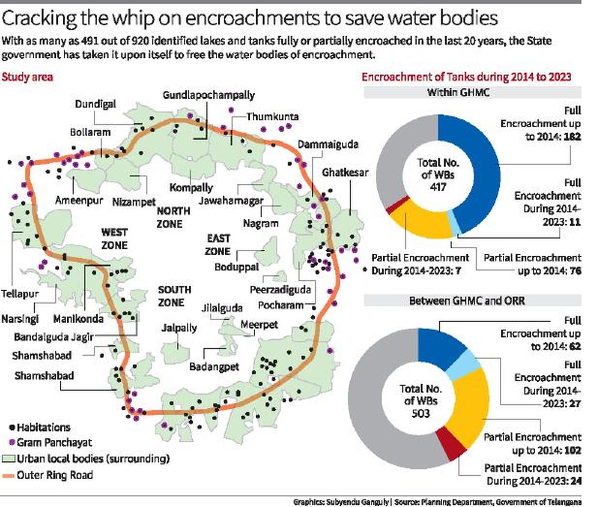
Mr. Bhatti Vikramarka reeled out interesting data to show how the water bodies have been encroached for the purpose of construction of building. He pointed out that till 2014 the total number of water bodies within GHMC limits and between GHMC and ORR were 920. In GHMC limits it was 417 of which 182 were fully encroached and 76 partially encroached and four were put to use for agriculture purpose partially. Between GHMC and ORR, there were 503 water bodies, and the officials found 62 fully encroached and 102 partially encroached in addition to 34 fully put to use for agriculture purpose and another 57 partially for the same purpose. In all practical purpose, there were 422 water bodies were recorded as encroached.
By 2023, there were same number of 417 water bodies but the full encroachments rose to 193 water bodies and 83 partially apart from one fully put to use for agriculture purpose and three partially. Between GHMC and ORR, of the 503 water bodies, 89 were fully encroached and 126 partially encroached and 68 were put to use for agriculture purpose fully or partially.
So the TGRAC came to a conclusion that the full encroachments up to 2014 in GHMC were 182 and between GHMC and ORR 62 making it in all 244. Between 2014 and 2023, it was 11 within GHMC and 27 between GHMC and ORR making it a total of 38 fully encroachments. There were partial encroachments numbering 76 in GHMC and 102 between GHMC and ORR up to 2014 and 31 (seven GHMC and 24 between GHMC-ORR).
The Deputy Chief Minister said with the report made available by TGRAC it would not be easy to take up remedial measures like removing encroachments and demolishing the illegal structures in phased manner. He hoped that over a period of time, the water bodies would be able to regain their old glory.
Images are for reference only.Images and contents gathered automatic from google or 3rd party sources.All rights on the images and contents are with their legal original owners.


Comments are closed, but trackbacks and pingbacks are open.