
Monsoon active over northern plains, 28% excess rainfall recorded in August so far
Monsoon is unusually active in August as incessant and heavy rainfall has pushed the total precipitation to an excess of 7% since June 1, with 28% surplus rainfall in just the first 12 days of this month.
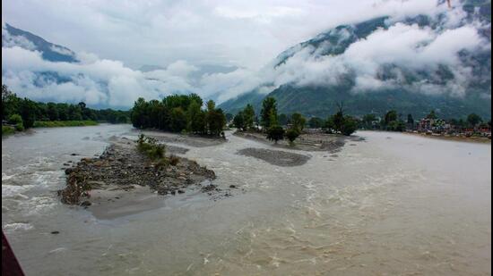
The Beas river flows in spate following torrential rain in the hilly parts of northern India. (ANI Photo) (ANI Photo)
Heavy rains have battered the northern swathes of the country, causing floods in several places including Delhi, Chandigarh and Gurugram. According to the weather department, heavy rainfall is likely to continue over Rajasthan, Uttar Pradesh, east and northeast India over the next 7 days.
The India Meteorological Department has warned of isolated heavy to very heavy rainfall over Kerala, Tamil Nadu, south interior Karnataka and the Rayalaseema region in the next five days.
In August, northwest India has received 55.7% of excess rain so far, while east and northeast India has received 46.8% excess precipitation. Central India and the southern peninsula have recorded 13.1% and 2.7% excess fall, respectively. July recorded 9% excess rain while June recorded a deficit of 11%.
“There are multiple weather systems at play. There are currently two cyclonic circulations, one over northeast Rajasthan and the other over southeast Uttar Pradesh. The monsoon trough is over the Indo-Gangetic Plains region and is very active. It is likely to remain over the same area for the next 4-5 days. So, there will be more rain this week. We ae not expecting a break in the monsoon over the next week. Rainfall has picked up in August also because ENSO neutral conditions have set in, which is supporting monsoon,” said Mahesh Palawat, vice president, climate and meteorology at Symet Weather.
A cyclonic formation lies over northwest Madhya Pradesh and its neighbourhood, extending up to the mid-tropospheric levels, while another trough is running from the cyclonic circulation to Bangladesh. A cyclonic circulation is also lying over southeast Pakistan and adjoining Rajasthan at lower tropospheric levels. The monsoon trough is near its normal position at mean sea level and is likely to oscillate near its normal position during most days of the week. This would mean more rainfall across northwest India.
Further, the weather department said a trough is moving from northeast Arabian sea to the cyclonic circulation over northwest Madhya Pradesh and neighbourhood in lower tropospheric levels. Another trough is also running from Rayalaseema to Comorin area and another cyclonic circulation is lying over northeast Assam extending up to mid-tropospheric levels.
There is a ‘red’ alert for east Rajasthan (extremely heavy rain over 20 cm) on Monday, while there is an ‘orange’ alert for very heavy rainfall (12-20 cm) at isolated places over West Madhya Pradesh, Rayalaseema, Assam, Meghalaya on Monday; Uttarakhand, East Rajasthan on Tuesday; Arunachal Pradesh on Tuesday and Wednesday; Tamil Nadu, Puducherry and Karaikal, South Interior Karnataka, Kerala until Wednesday.
There is also a low to moderate flash flood risk over a few watersheds and neighbourhoods of Himachal Pradesh, Uttarakhand, East Rajasthan, West Madhya Pradesh, coastal Karnataka, Kerala and Mahe, and south interior Karnataka met sub-divisions on Tuesday, the IMD has warned.
Latest model outputs indicate that transition to La Niña may be delayed. IMD’s Monsoon Mission Climate Forecast System (MMCFS) indicated that La Niña conditions are likely to develop during the second half of the monsoon season. The National Oceanic and Atmospheric Administration of the US had issued a La Niña watch in May, indicating that La Niña conditions are expected to form soon. The La Niña watch issued last week said it could form as early as June-August 2024.
But the Indian National Centre for Ocean Information Services (INCOIS) said on August 5 that the sea surface temperature anomaly signature in the eastern and Central Pacific shows the near neutral ENSO condition continued in July as well.
“The probability for the Pacific Ocean to remain in ENSO neutral condition is high until October. From November to January, the probabilities for the neutral conditions to continue or La Niña event to develop are almost equal (45-60%). “The probability for the Pacific to remain in ENSO neutral conditions is high from February to April 2025,” INCOIS said.
“Yes, La Niña has not really developed in full swing. Nino 3.4 index has become negative but below 0.5 degree C (Needed to declare La Niña) It is getting delayed but may develop towards end of monsoon. Because this will be active in September also,” said M Rajeevan, former secretary, ministry of earth sciences and climate scientist.
Images are for reference only.Images and contents gathered automatic from google or 3rd party sources.All rights on the images and contents are with their legal original owners.
Comments are closed, but trackbacks and pingbacks are open.