
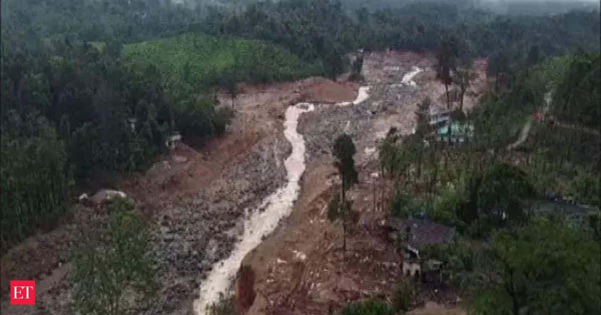
86,000 sq metres of land slipped away, debris travelled 8 km along Iruvanjippuzha river: ISRO satellite images reveal
As the trajedy that claimed over 300 lives rocks the nation, satellite images from National Remote Sensing Centre (NRSC), a key centre under ISRO unveiled that nearly 86,000 square metres of land slipped away, and the resulting debris flow travelled about 8km along the Iruvanjippuzha river, devastating towns and settlements in its path.
NRSC, located in Hyderabad, reports that the landslide originated at an altitude of 1,550 metres above sea level near the town of Chooralmala. Notably, the Isro report indicates evidence of a previous landslide at the same location, suggesting the area’s known vulnerability.
“A major debris flow was triggered by heavy rainfall in and around the Chooralmala town of Wayanad. Very high resolution Risat SAR (synthetic aperture radar) images of July 31 shows the entire extent of the debris flow from crown to end of runout zone. The approximate length of the flow is around 8km. The crown zone is a reactivation of an older landslide,” said the report on the landslides.
“… Size of main scarp of the land- slide is 86,000 sq m. The debris flow has widened the course of Iruvanjippuzha river, causing breach of its banks. Houses and other infrastructure along the banks have been damaged by the debris flow,” the report added further.
In February 2023, India’s national space agency released the Landslide Atlas of India, which documented around 80,000 landslides across 17 states and two UTs in the Himalayas and Western Ghats from 1998 to 2022. It includes seasonal, event-based, and routewise inventories, using high-resolution satellite and aerial imagery.
The atlas, which covered major events from the past, such as Kedarnath disaster and Sikkim earthquake, had ranked 147 districts based on landslide exposure and socio-economic factors. Wayanad was placed among the vulnerable districts. The database was partially field-validated and includes advanced techniques for landslide detection, modelling and prediction.(with ToI inputs)
Images are for reference only.Images and contents gathered automatic from google or 3rd party sources.All rights on the images and contents are with their legal original owners.
Comments are closed, but trackbacks and pingbacks are open.